Unlocking the Secrets of the Seabed

Boats and Equipment

SURVEY BOAT

Marathon is a Striker 44 aluminium hull Sports fisher/cruiser built in the Netherlands in 1972. Completely refitted in 2013, she is the ideal platform for marine surveying work in our coastal waters.

Home Port: St Helier, Jersey

Particulars: Length: 14.5m  –  Beam 4.2m –  Draught: 1.2m –  Speed: 4.5 to 23 knots

Power: 2 x Volvo Penta M600 Marine diesel engines

Panda 7.5 kw Generator

Seakeeper 5 Gyro-stabiliser

Trimble BX992 GNSS Receiver and antenna for precise positioning and navigation.

Norbit WBMS Tx Multibeam sonar for ultra-high resolution with integrated sound-velocity sensor for precision mapping of the sea-bed.

SMC IMU 108 Motion Reference Unit for Roll, Pitch and Heave.

BeamworX Autoclean Navigation and acquisition software

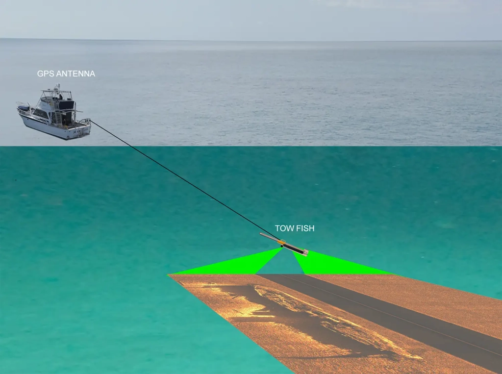
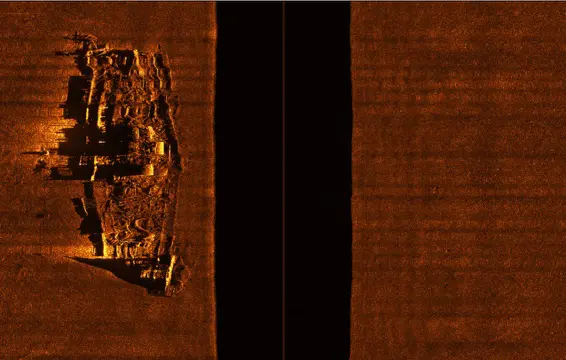
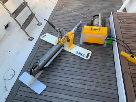
C-Max 2 Side Scan Sonar and deck winch and A-Frame

SeaSpy2 Marine Magnetics Magnetometer and 250m cable

Multibeam Sonar

Multibeam sonar is a technique used to map the seafloor and create detailed 3D bathymetric maps: The sonar sends out multiple sound waves in a fan-shaped pattern, simultaneously, from a transducer array mounted on the ship’s hull. The time it takes for the sound to return to the array after hitting the seafloor is measured to calculate the seafloor depth, or bathymetry.

This technology is widely used in a variety of applications, including underwater geological mapping, shipwreck search and research, and marine environmental monitoring. The hull-mounted sonar transducer/receiver can be operated at speeds of up to 11 knots, enabling rapid coverage of large areas of the seabed. Marathon is equiped with a Norbit WBMS Tx Wide Band Multibeam Sonar, 460 to 700 kHz for ultra-high-resolution images.

The main advantage of slide scan sonar lies in its ability to provide a full visualization of the scanned area, allowing researchers, oceanographers and other interested parties to better understand the characteristics of the seafloor and other underwater phenomena. The towfish is usually towed behind the surface vessel at speeds of between 2 and 5 knots.

An accurate map of the object’s position can be created by recording the sensor’s position along with the magnetic variation. The magnetometer is installed in a water-tight tow fish, which is towed behind the vessel using a tow cable. Marathon is equipped with a Marine Magnetics SeaSpy Explorer magnetometer with an Overhauser sensor.

© 2025 - Channel Islands Hydrographic Survey