About Us

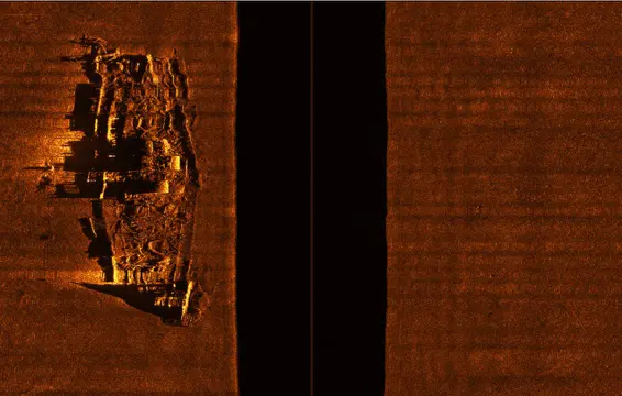
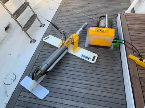
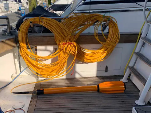
Channel Islands Hydrographic Survey (CIHS) is a bathymetric seabed mapping project launched in 2025 to survey and chart specific areas and features of the seabed within the territorial waters of the Channel Islands using modern sonar technology while utilizing and developing locally based island expertise and resources.

This will hopefully encourage cost-effective solutions while promoting the best use of local hydrographic skills and resources in preparation for future surveys of all of our territorial waters.

Exploring for Shipwrecks

Shipwrecks are an integral part of our submarine landscape and maritime heritage. The waters of the Channel Islands contain hundreds of known and as yet undiscovered shipwrecks from all ages.

Our aim is to find and survey as many of these wrecks as possible using ultra high resolution multibeam and side scan sonar equipment, at an adequate special resolution to establish a comprehensive database for future monitoring initiatives. Other techniques will be used as progress is made and the database is expanded.

With the help of local fishermen, divers and marine archaeologists, we hope to locate and survey as many of the known shipwrecks as possible in order to provide a high-quality database. The project will commence within the territorial waters of the island of Jersey but will also include specific sites within the waters of the Bailiwick of Guernsey.

A Seabed Mapping Initiative for the Channel Islands

Primary marine bathymetry datasets derived from full coverage high resolution multibeam sonar surveying, is critical for the development of marine knowledge, economy, and policy, as well as the protection of the marine environment of the Channel Islands.

Exposed to view of our advanced sonar technology, the Island’s waters reveal a fantastic array of submarine cliffs, sweeping sand dunes as well as a multitude of diverse marine habitats just waiting to be explored by oceanographers, marine scientists and intrepid divers. Many of these unexplored habitats will be candidate for protection and the data we collect will be a crucial starting point for this work.

Almost all activities in the ocean are underpinned by marine geospatial data. Our aim is to collect high-quality bathymetric data to UKHO standard S-102 for submission and validation by the Admiralty to support safety of navigation, environmental and scientific study.

Science, Collaboration and Education

The survey data will provide an important resource for informing multiple disciplines and become accessible to the broader scientific community, supporting research, maritime archaeology and public engagement. Through collaboration with UK universities we hope to explore and map areas of special scientific interest in Channel Island Waters and make the data available for future research.

Discover Our Maritime History and Our Amazing Seabed

Launch Date: August 2025

PHASE 1: Summer 2025

10 shipwrecks, 10 Seabed features of special Interest and 5 Sites of Special Scientific Interest to be mapped.

The bathymetric datasets will be uploaded and displayed on the Seabed Viewer.

Details of each shipwreck will be published, and links provided to other databases when available.

Datasets will be regularly uploaded to the Seabed Viewer. This will be patchy at first but will develop over time.

Boats and Equipment

See what we use to find stuff

Operational Updates

Find out what we’re up to

Multibeam Sonar

Multibeam sonar is a technique used to map the seafloor and create detailed 3D bathymetric maps: The sonar sends out multiple sound waves in a fan-shaped pattern, simultaneously, from a transducer array mounted on the ship’s hull. The time it takes for the sound to return to the array after hitting the seafloor is measured to calculate the seafloor depth, or bathymetry.

This technology is widely used in a variety of applications, including underwater geological mapping, shipwreck search and research, and marine environmental monitoring. The hull-mounted sonar transducer/receiver can be operated at speeds of up to 11 knots, enabling rapid coverage of large areas of the seabed. Marathon is equiped with a Norbit WBMS Tx Wide Band Multibeam Sonar, 460 to 700 kHz for ultra-high-resolution images.

The main advantage of slide scan sonar lies in its ability to provide a full visualization of the scanned area, allowing researchers, oceanographers and other interested parties to better understand the characteristics of the seafloor and other underwater phenomena. The towfish is usually towed behind the surface vessel at speeds of between 2 and 5 knots.

An accurate map of the object’s position can be created by recording the sensor’s position along with the magnetic variation. The magnetometer is installed in a water-tight tow fish, which is towed behind the vessel using a tow cable. Marathon is equipped with a Marine Magnetics SeaSpy Explorer magnetometer with an Overhauser sensor.

© 2025 - Channel Islands Hydrographic Survey